Gran Canaria, Italy, and Everesting

This week, Klaus takes us to Spain, Italy and gives us a loop that would be suitable for a virtual Everesting for those of you mad enough to try it, the Kreuzberg Virtual Everesting Loop.

If you’re attempting a Virtual Everesting on this circuit, it’s 22 laps.

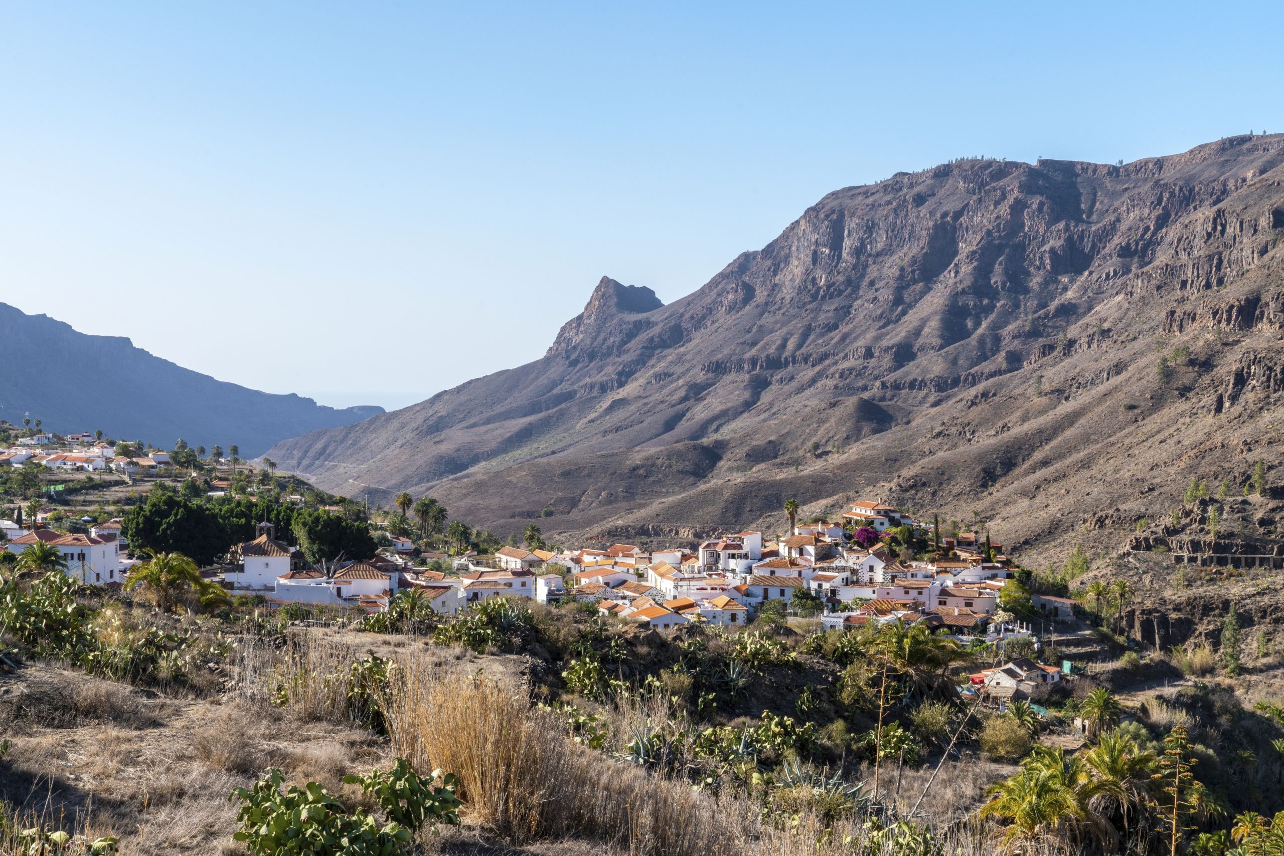
Klaus describes this Gran Canaria series as full of “Blue skies, seemingly endless climbs and stunning Spanish countryside are all hallmarks of these rides from Spain – discover why Gran Canaria is the favourite cycling destination in the European winter and spring season!”

There’s also two bonus Italian rides, for those fans of Klaus’ routes.

MOGAN TO SAN NICOLAS VIEWPOINT

Start in the valley of Puerto Mogan close to the harbor. Instead of turning right into Barranco Mogan, this time we go left and cycle all the way on the very scenic GC505 to the San Nicolas viewpoint.

More Info
20.04km
DISTANCE
01:02:07
DURATION
678m
ELEVATION

ANFI TO TAURITO LOOP

An easy loop through all the very well known places along the southern coast of Gran Canaria. The road to Puerto Mogan is closed for cars and bikes since end of 2019 so the loop only goes to Taurito and then back to the start.

More Info
23.94km
DISTANCE
00:51:06
DURATION
361m
ELEVATION

PUERTO DE MOGAN > PICO DE LAS NIEVES

The Queen Stage of Gran Canaria rides! An almost 3 hour/45km long ride starting in Puerto de Mogan and finshing on top of the highest mountain on Gran Canaria - the Pico de las Nieves. There are only a few slight descents in this ride but the grades are mostly in the 5-7% range. Its tough, but you will be rewarded with fantastic views throughout the ride and especially at the end.

More Info
45.18km
DISTANCE
02:45:04
DURATION
2057m
ELEVATION

TASARTE

A lesser-known but nevertheless quite scenic ride from almost sea level up through the valley of Tasarte. You can still see some traces of a recent dangerous forest fire and the smell was not good. Once back on the main road, enjoy a nice descent with many views and relax from the previous efforts.

More Info
12.27km
DISTANCE
00:47:13
DURATION
614m
ELEVATION

RUTA DE LAS PRESAS (VOT)

Ruta de las Presas - also known amongst cyclists as "Valley of Tears" could also be named valley of sweat and probably has its name from numerous cyclists cursing the heat and the always steep to very steep grades. Don't forget that one usually has already a couple of hundert meters of climbing in the legs before entering the VoT. Try to enjoy the views - as far as the next island Teneriffe!

More Info
14.60km
DISTANCE
01:20:49
DURATION
1051m
ELEVATION

MASPALOMAS TO AYACATA

Probably THE other ride in Gran Canaria that most cyclists will do on GC. It starts flat on the coast in Maspalomas, but soon gets steeper and you are rewarded with great views in many places. The ride ends after about two hours at the well visited and very well known (bike) cafe in Ayacata.

More Info
33.25km
DISTANCE
01:59:02
DURATION
1482m
ELEVATION

PICO DE LAS NIEVES

Climb the highest mountain in Gran Canaria! The ride starts in Ayacata, right at the famous local cafe where always lots of cyclists gather. It is the short version of the Barranco Mogan to Pico de las Nieves ride to give you the opportunity to enjoy the view at the summit on a much shorter ride!

More Info
11.32km
DISTANCE
00:47:35
DURATION
674m
ELEVATION

AYACATA TO CRUZ DE SAN ANTONIO

A short ride which starts with a long descent at the well known cycling stop at Ayacata. Contrary to real life, you won't feel the bad road so much (one of the worst stretches in Gran Canaria). Enjoy the curvy road up to Tauropass with moderate gradients on the now perfect road and get a glimpse at the Barranco Mogan at the end.

More Info
14.60km
DISTANCE
00:25:47
DURATION
86m
ELEVATION

BARRANCO DE LAS ALDEA

Barranco de la Aldea is one of the few "hidden gems" of Gran Canaria. It starts close to San Nicolas on the western coast. There is almost no traffic here because the road is very narrow and had very bad tarmac. The scenery is just breathtaking throughout the route which is full of turns and up and downs. Enjoy the views, admire the dams, lakes and surrounding hills. Prepare for the subsequent ride into the Valley of Tears!

More Info
10.13km
DISTANCE
00:37:25
DURATION
479m
ELEVATION

BARRANCO MOGAN

One of the most beautiful climbs in Gran Canaria. Start at almost sea level and gradually ascent on the main road until you cross into the Barranco Mogan. The scenery changes quickly as the ride climbs through numerous switchbacks on a perfect road with an always fascinating scenery. One forgets that this climb ascents almost 1000m!

More Info
17.54km
DISTANCE
01:08:37
DURATION
899m
ELEVATION

CLIMB OUT OF THE ETSCH VALLEY

One of the hidden gems close to Bolzano. Start near the Etsch river and find your ways on the rather steep road up to Mölten. Enjoy frequent views of the Etsch valley below while climbing up.

More Info
12.84km
DISTANCE
00:55:09
DURATION
898m
ELEVATION

HIGH ABOVE THE ETSCH VALLEY

Yes - the start is rather steep in Mölten. However, after the first 10 minutes we cycle many km on undulating roads high above the Etsch valley with lots of fast descents to recover your legs. After we pass the well-known ski-area "Meran 2000" be prepared for a high speed descent with breathtaking views of Merano. The finish is right at the Etsch river in the center of the beautiful city.

More Info
26.81km
DISTANCE
00:58:13
DURATION
446m
ELEVATION

KREUZBERG VIRTUAL EVERESTING LOOP

TEST ROUTE: This is a test for a virtual Everesting route. One Loop is 13km and each climb is around 415 metres of ascent. The average gradient is around 7% and the original rider averaged 4w/kg for the climb. The Strava segment for this climb is: https://www.strava.com/segments/658537 A full vEveresting ride would be roughly 22 laps of this course!

More Info
12.91km
DISTANCE
00:29:53
DURATION
415m
ELEVATION

ARGUINEGUIN TO MELONERAS LOOP

A quick and fast loop along the beach road from Arguineguin to Meloneras and back. Can be used for time trialing but also to just enjoy the views on this winding road!

More Info
13.20km
DISTANCE
00:28:56
DURATION
244m
ELEVATION

FRANCONIAN WINDMILL RIDE

An early evening ride in Lower-Franconia, through what I call the "Windmill" country. Undulating terrain, awesome views, a clear blue sky and very little traffic make it an enjoyable ride - which was done with some speed. Enjoy!

More Info
21.27km
DISTANCE
00:44:22
DURATION
422m
ELEVATION

Subscribe to FulGaz

Now available on a wide choice of platforms including Android, Apple TV, iPad, MacOS, iPhone and Windows. FulGaz offers you the ultimate ride!

Pricing