Monster California Rides with Alex Berthillier
Join Alex Berthillier on a tour across southern and central California, USA.
This ride collection is spicy, so get ready for a serious quad-burn.
If you’re looking for a challenge, tackle Mount Figueroa, one of Southern California’s toughest climbs, with an average gradient of 8%.
Find all these rides under NEW in the FulGaz App.
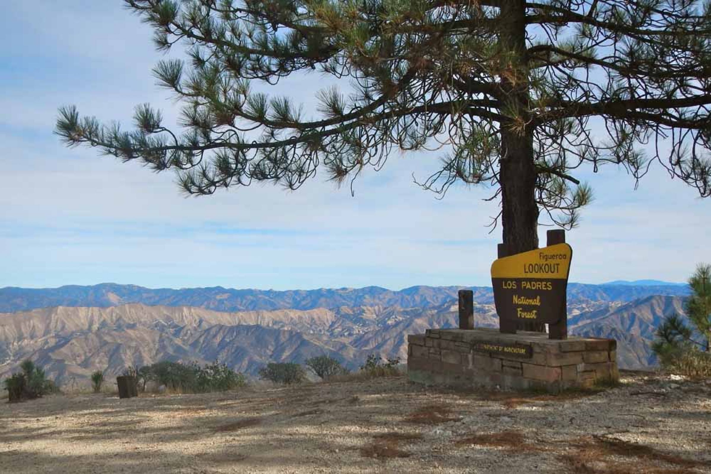
FIGUEROA MOUNTAIN
The Mount Figueroa loop is one of the best-known rides in the Santa Barbara region - and it’s a beast. With an average gradient at around 8%, it’s one of the toughest Southern California cycling climbs. It’s also one of the prettiest. Climbing it by bike is a serious endeavour, but conquer it and you’ll be rewarded with epic views across the Los Padres National Forest and the San Rafael Mountains. The climb begins in earnest at around 17 km, and the gradients kick in steeply from the start. It’s 5km to the top of the first ridge with an average 7.7% gradient. Not leg-breaker hard, but tough all the same, particularly due to the unpaved 1.6km (1 mile) section. The narrow road to the top is cut into the forested mountainside, and you’ll need to watch out for patchy asphalt and debris on the road. Make the most of the stunning views to your left and right as after a final, short, sharp climb you reach the unremarkable, no-view, forested summit.
More InfoOLD MOUNT MADONNA ROAD
Mount Madonna is a very remote climb nestled into the redwoods with no traffic. Half of the route is paved, but the second half, the higher elevation portion of the climb, is unpaved dirt making it a challenging adventure.
More InfoJALAMA BEACH
This ride takes you from Solvang to Jalama Beach. Land near Jalama Creek was once a Chumash Indian settlement named "Halama". In 1943, 23.5 acres of privately owned land was donated to the County of Santa Barbara from the Atlantic Richfield Oil Company, and thus, our park was formed. Jalama Beach is a respite from typically bustling seaside parks, approximately an hour drive from Santa Barbara and a 45-minute drive from Lompoc. A sign 4.5 miles south of Lompoc off Highway 1 will direct you onto Jalama Road, a scenic 14.5 mile road to the coast. Jalama is subject to high winds and rough surf. Lifeguards are on duty during the summer months, however visitors swim at their own risk.
More InfoREFUGIO ROAD
Refugio Road is a stunning climb into the coast mountains west of Santa Barbara. A very narrow, twisty and variable grade road takes you up the hill, often under a tunnel of trees near the bottom. A steep switchback to the left...several miles in will get your attention as the trees begin to thin. Continuing over a variable grade, at mile 5.2 you reach a junction. From here (turn right...) the road is a true single lane and hugs the cliffside in places. Continuing over a narrow road and a variable grade, the route is exposed for the majority of the 2nd half of the ascent. The steepest climbing is at the very end as there is a double digit grade ramp just before the road dead ends at a cell tower facility.
More InfoHAZEL DELL ROAD TO EUREKA CANYON ROAD
Eureka Canyon Road begins in Corralitos; it’s a quiet remote climb through the wooded canyon to the summit at Highland Way & Ormsby Trail. It’s 8.8 miles with gradient ranges of 4-8% and a few steep pitches of 10-11% along with an elevation gain of approx 1629 feet. The road weaves along the lines of Corralitos Creek from Browns Creek to the upper highlands.
More InfoDRUM CANYON AND TEPUSQUET CLIMB
This rides take us over four nice climbs: Drum Canyon, Cat Canyon and the two sides of the Tepusquet Mountain. Starting with mellow climbing, soon the road becomes a one way road and a bit steeper to the summit of Drum Canyon, and after a quick downhill, it is time to go over Cat Canyon and see the oil rigs all over the field. After riding a bit on Foxen Canyon, we'll need a harder gear to climb both sides of Tepusquet. Climb without interruption at a moderate pace to the summit pass at 9.6 miles. The back side of the ride is a notch steeper and much curvier for the next 3 miles, with some very nice banking in the constant switchbacks. Here you can really practice your cornering skills. You’re on the drier north side of the divide now, so the landscape is harsher, but the payoff is great vistas of the grand valley before you and the hills beyond. And you can see your own road ahead of and far below you - always a thrill.
More Info